Most of the earth’s continents are girded by shallow shelves that slope gently away from the land for many miles, their depths seldom greater than a few hundred feet. On the East Coast of the United States, the shelf stretches for more than one hundred miles in many spots, before giving way to a steep slope that drops into the abyss. On the West Coast, the shelf is narrower but still a substantial barrier to the deep. Off Monterey, things are different. Here an enormous canyon cuts the continental shelf in two, bringing deep water remarkably close to land The canyon is so close that erosional forces at its tip keep nibbling away the old pier at Moss Landing, located at the bay’s midpoint. The dilapidated pier used to be twice as long, but with troubling regularity its leading edge keeps tumbling into the head of the invisible canyon.
—William J. Broad, Dimitry Schidlovsky, The universe below: discovering the secrets of the deep sea, 1998
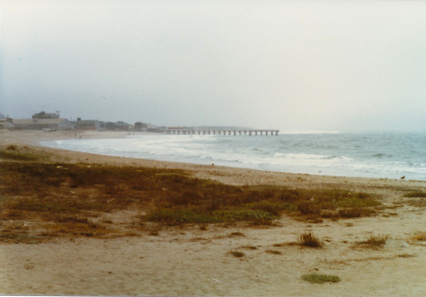
Situated mid-way between the more heavily populated areas of Monterey and Santa Cruz is the small port of Moss Landing. Stay on HY 1 and you will zip through the town in less than 30 seconds. Get off the highway and you find several restaurants, a couple of tourist shops, and a bay full of commercial fishing boats. Head out along Sandholdt Road and you are basically on a sand spit with the bay on one side and the ocean on the other. You will not see much of the beach because most is closed to visitors but you will see the impressive Moss Landing Marine Laboratories, Phil’s Fish Market (home of the famous Cioppino Throwdown with Bobby Flay), and eventually you come to the jetty and the end of the road.
If you’re an angler you can fish the surf area and beach which, in this stretch of Monterey Bay, usually produces good catches of the surf species—mainly barred, calico, and walleye surfperch; if lucky you may land a striped bass. The jetty that gives entrance into the bay is an equally good producer of fish for the rock fishermen navigating the large (and sometimes slippery) rocks. Here the fish mix changes to the rock dwelling species—striped seaperch, rockfish, cabezon, lingcod and an occasional monkeyface eel. The bay itself produces a wide variety of fish and it connects to Elkhorn Slough, an area once noted for an annual shark derby (and won most years by bat rays exceeding 100 pounds).
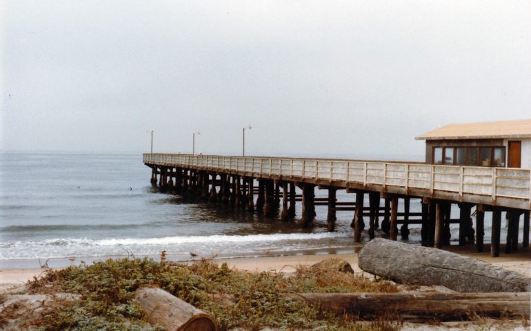
The Sandholt Pier — 1978
What you will not see is a pier or pier fishermen; pier rats are no longer part of the local angling fraternity. The small pier mentioned above, the wooden pier simply called the Moss Landing Pier by most (but more properly called the Sandholdt Pier), a pier used by both locals and visitors, is now history.
The death of the pier was perhaps predictable; it’s a story that has been repeated many times at piers all along California’s coast. Big storms, often generated by El Niño conditions, create powerful winds, huge waves and tidal surge that have affected every pier at one time or another; some survived, some didn’t. Here it was a combination: punishing storms (1995 and El Niño years), damaging high waves (1999), and an earthquake (1989’s Loma Prieta Earthquake). Mother Nature, together with (perhaps) simple old age and inadequate upkeep, led to a loss of pilings and the tilting of the pier’s deck Authorities feared the pier’s collapse and talked of a threat to public safety. In response, the pier was demolished in 2002. Who knows how many feet of the pier simply tumbled into the head of the invisible canyon as described in the opening paragraph?l
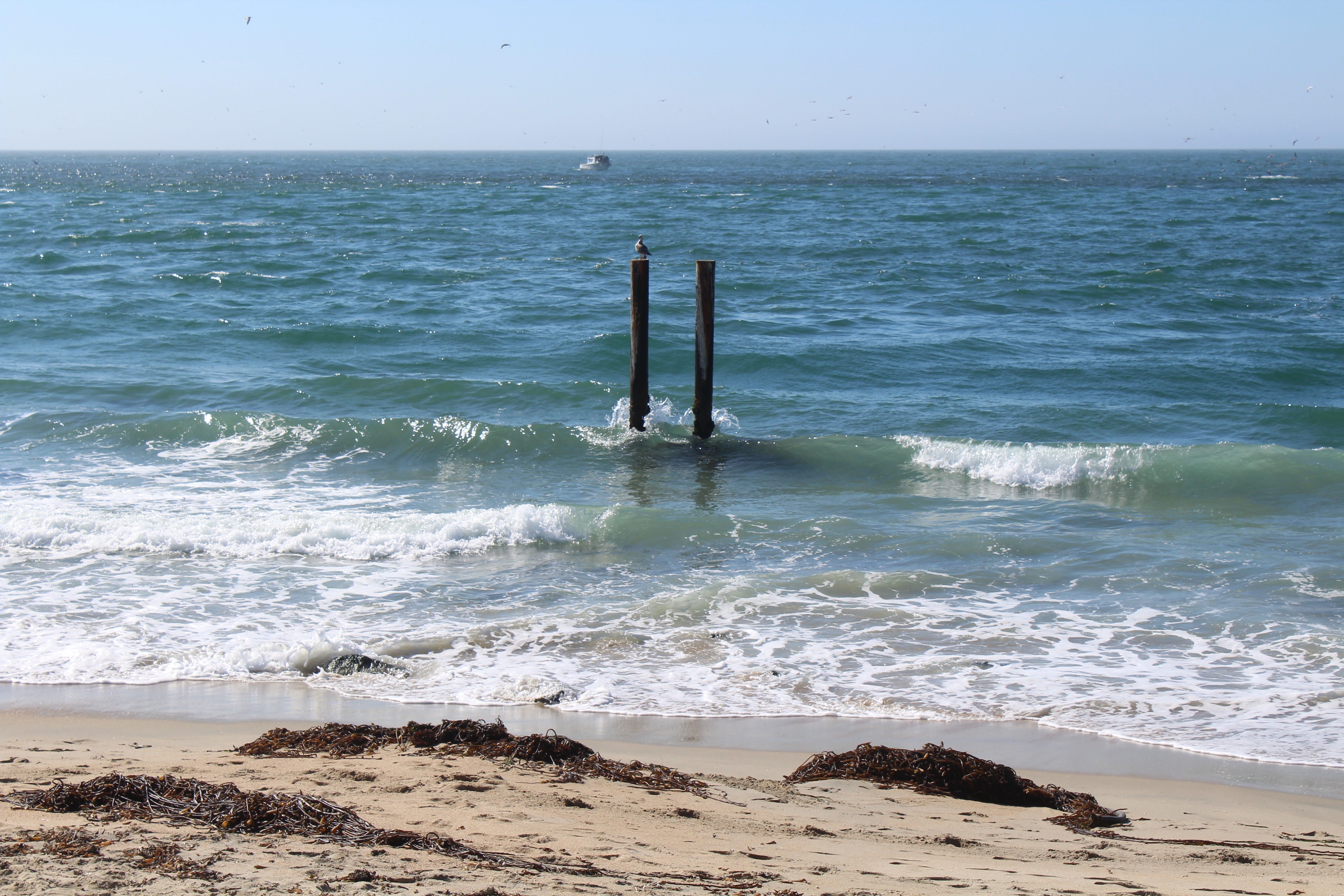
What appears to be a couple of pilings from a former pier
Stand on the narrow shoreline by where the pier once stood and you’ll see the sea, perhaps a boat or two, the almost always present sea birds, and two lone pilings sticking up above the water seemingly as testament to the once popular pier.
Luckily I was able to make a couple of visits to the pier back in the late ‘70s. I didn’t catch a lot of fish but the barred surfperch I caught were good-sized and I enjoyed the visit with my kids. But, as said, it’s history.
Nevertheless, it’s still a little unclear why there is no pier. Many clamored for a new pier and, the California Coastal Commission clearly seemed to want some type of public pier built.
“The primary Coastal Act issue raised by the project is the protection and the provision of maximum access and recreation opportunities, as required by Chapter 3, Article 2. The Monterey County certified LCP, which provides guidance to the Commission, also require the protection and enhancement of coastal access and recreation opportunities, and specifically recommends restoring the former Sandholdt Pier as a fishing pier. In addition, the LCP encourages the use of existing piers for access and recreation where compatible with commercial fishing. Maximizing public access and recreation opportunities are particularly warranted given the project’s use of public land and financing.
In contrast, the plan submitted for approval by the Moss Landing Marine Laboratories called for a 500-foot long. 12,832 square foot concrete pier, a pier designed to be used by research vessels from the laboratories and to be OFF LIMITS to the public. Concern was expressed that even with controlled access the public might damage equipment and/or laboratory conditions. In addition, it said there was a risk to the public and resulting liability — “The pier will be equipped with high voltage, dangerous heights and millions of dollars worth of scientific equipment and projects.” As a minimal nod to the public, and a begrudging acceptance of direction from the Coastal Commission, the Laboratory did agree to a thousand square foot viewing area. Pier fishing though would be verboten, totally forbidden. The fear was that anglers inevitably would do damage of some type. The argument was debatable but not surprising given the state of affairs in “modern day” California.
But the words of the Coastal Commission seemed pretty clear:
In contrast to Coastal Act and LCP access policies, the public access plan submitted by the applicant provides only limited access opportunities on the pier, in the form of escorted tours and occasional open house events, due to concerns about protecting equipment and research activities. As detailed in the findings of this report, the submitted plan does not adequately explore measures that could be used to accommodate some form of general public access in a manner that is compatible with research, safety, and resource protection needs. Therefor, the recommended conditions of approval require the applicant to further evaluate such options, and to re-submit and implement an expanded access plan that maximizes compatible access and recreation opportunities to the satisfaction of the Executive Director.”—California Coastal Commission, Coastal Development Permit Application, F7a, Filed: December 26, 2004, 180-day: June 24, 2005
After all that the staff recommended approval of the application.—which to date has not been built.
As for a fishing pier, It’s sad that one does not exist at Moss Landing given the gap between the nearest pier to the south—Monterey Wharf #2 and the nearest pier to the north, the Seacliff Pier (which itself is in disrepair). And though the Moss Landing Harbor is crowded with wharves there is not a single wharf or pier that is open to recreational anglers (which perhaps shows their lack of importance to the community).
It’s a shame because the pier that once graced the spot offered up some truly unusual fishing at times and had one of the highest fish-per-angler-day figures of the central coast piers.er part of the mix.
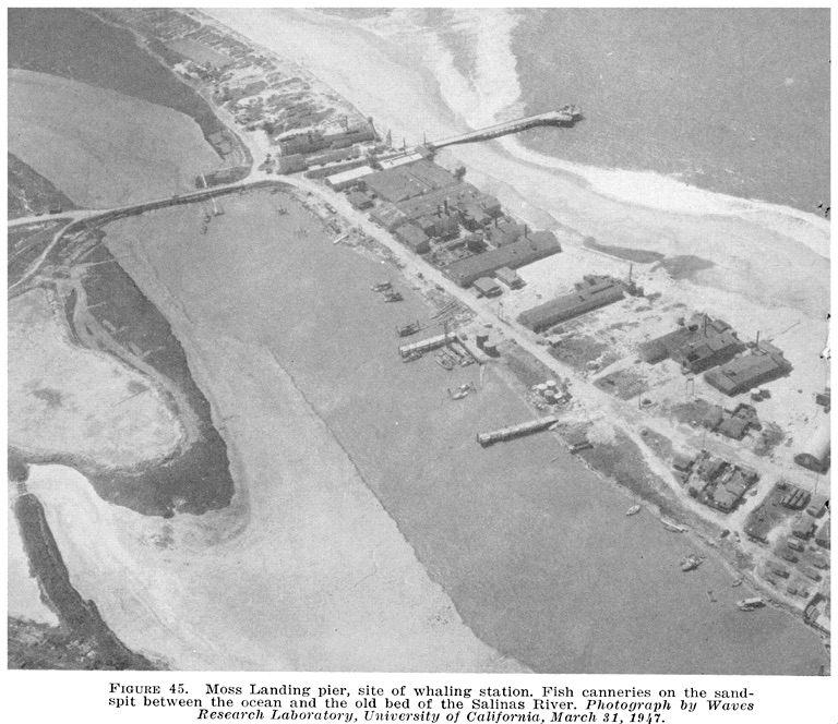
From California Fish Bulletin #96 — 1953
Environment. Although at first glance this area simply appears to be another sandy-shore beach area, looks are deceiving. Hidden offshore is the Monterey Submarine Canyon, one of the largest underwater canyons in the world, and certainly one of the most studied. Comparable in depth and length to the Grand Canyon of Arizona, it’s the West Coast’s largest such canyon. And, after more than a 90-mile length, and from a 12,000-foot depth, the canyon rises and funnels into Moss Landing.
Within a hundred yards of the shoreline is where the Canyon begins, or ends, depending upon your view, and provides a unique deep-water habitat fairly close to shore. The proximity to the canyon led to the special nature of this pier—the occasional catch of a deep-water species that had followed the canyon’s highway up toward the beach. Strange species were not a daily, or even common occurrence, but the possibility of such species made the pier special.
More commonly caught were the typical surf species: surfperch, white croaker, jacksmelt, flounder and sole. But it was always the possibility of those more exotic species that was the main attraction of the pier to me (and other similar-inclined amateur ichthyologists).
One unusual fish I did see caught here, although actually not a deep-water fish nor a typical sandy-shore species, was a wolf eel (Anarrhichthys ocellatus). What was most interesting about this fish was the power of its jaws. An angler had caught the wolf eel while fishing on the bottom with a piece of anchovy, and the fish had swallowed the hook. Most anglers would simply have tied on a new leader when they saw the teeth in the nearly four-foot-long eel. But no, this angler wanted to save his hooks. His solution was to insert a small broom handle (about the thickness of a half-inch dowel) into the mouth to prop it open. It didn’t work! The wolf eel bit through the handle, and the angler decided to retrieve his hooks after the fish was dead. A smart move I might add.
<*}}}}}}}}}>< — Although figures can change greatly from year to year, and season to season depending upon water temperature and other factors the various studies give a glimpse to both numbers of fish and species.
One such report was CA Fish and Game Dept., Administrative Report No. 82-9, Species Composition and Catch per Unit of Effort of Monterey Bay Surf, Pier, and Skiff Anglers in 1979: “In 1979, Monterey Bay sport anglers were sampled for species composition of the catch and catch per unit of effort. A total of 4,150 surf, pier, and skiff anglers were interviewed. Fish per hour was… .58 for piers. The species composition of the pier catch was dominated by juvenile bocaccio, Sebastes paucispinis; white croaker, Genyonemus lineatus; and the walleye surfperch, Hyperprosopon argentum … a small privately operated pier inside Moss Landing Harbor had the best catch rate (2.44 fph) of all piers sampled.”
The Moss Landing Pier (oceanfront) showed a .99 fish per hour rating and the following top seven species: (1) Bocaccio 44%; (2) Walleye surfperch 16%; (3) Silver surfperch 10%; (4) Sanddabs spp. 9%; (5) Barred surfperch; (6) White croaker 4%; (7) Jacksmelt 1%.
The Moss Landing Partyboat Pier (in the harbor) had, as mentioned, the highest fish per hour rating of the six Monterey Bay piers surveyed at 2.44 fph. The pier showed the following top seven species: (1) Walleye surfperch; (2) Jacksmelt; (3) Bocaccio; (4) Brown rockfish; (5) Shiner surfperch; (6) White surfperch; (7) Staghorn sculpin. Mention is made in reference to the catch rate: “The best fishing pier was the Moss Landing partyboat pier where the catch rate was 2.44 fish per hour. This pier is a private pier where a fee is charged to fish and is only open during the summer and fall when fishing is at its best; this accounts for the higher catch rates.”
However, catch rates can vary considerably year to year. The 1979 survey showed Monterey Wharf #2 as the best public pier at 1.55 fph and the Santa Cruz Wharf as having the lowest catch rate at .32 fph. A similar study a decade earlier, in 1968, showed quite different results. Santa Cruz had the highest rate at 1.25 fph and Monterey Wharf #2 as one of the poorest at .50 fph.
The conflicting data simply shows the need for various studies over different times and years to get a true picture as to what a pier should offer.
Fish Bulletin 130, Department of Fish Game, Ocean Sportfish Catch and Effort From Oregon to Point Arguello, California July 1, 1957–June 30, 1961by Daniel J. Miller and Daniel Gotshall surveyed fishing areas throughout central and northern California. In regard to the Moss Landing Pier it reported the following species catch during 1958: 30 blue rockfish, 746 flatfish, 10,155 surfperch, 279 staghorn sculpin, 7,695 white croaker, and 17,092 jacksmelt. With the exception of the blue rockfish, all other species are typical sandy-shore species.
<*}}}}}}}}}>< — As said, the deep canyon waters funneling into the mouth of the bay would occasionally yield up some unusual deep-water species. Such was the case with the following:
“On July 5, 1968, while fishing off Sandholt Pier in Moss Landing, California, a fisherman, Ramon Castillo, hooked a 1020 mm (40.2 inch) Standard Length (sl) North Pacific frostfish, Benthodesmus elongatus pacificus (Parin and Becker, 1970), a species unknown in California. This interesting deep-water fish was brought to the Moss Landing Marine Laboratories and placed unidentified in the ichthyology research collection… During the summer of 1973, while reorganizing this collection, we rediscovered this specimen along with another slightly smaller individual that had no collection data, and identified both of them as Benthodesmus simony i, using keys to the family Trichiuridae (Tucker 1956) and to the genus Benthodesmus (Tucker 1953). Parin and Becker (1970) assigned the new subspecific designation, Benthodesmus elongatus pacificus, to five specimens from the western North Pacific collected by the Soviet trawler K/V Vityaz from 1958 to 1966, one specimen off Japan (Franz 1910), and one specimen off British Columbia (Gilbert 1917). Thus, these two specimens from Moss Landing not only add a new species to the California marine fish fauna but represent the second and third recorded collections in the eastern North Pacific Ocean.” —M. Eric Anderson and Gregor M. Cailliet, California Fish and Game, July 1975
<*}}}}}}}}}>< — Usually winter storms provide most of the damage to coastal piers but California also has something called earthquakes. “The wharf at Moss Landing buckled up and partly collapsed, while the warehouses were wrecked or fell westward… At Moss Landing many small cracks occur in the mud on the west side of the river, and the condition of the wharf indicates an eastward movement of the sand-spit… It is reported that at places along the pier where the water was formerly 6 feet deep, it now has a depth of 18 or 20 feet.” —The California Earthquake of April 18, 1906, Report of the State Earthquake Investigation Commission
History Note. Moss Landing is located on the Bay of Monterey at the mouth of the Salinas river, about three miles from Castroville, and has three extensive and commodious warehouses for the storage of grain, and a substantial wharf running out into the bay about 1000 feet, where vessels lie to take in grain. A regular line of steamers call twice a week. —Monterey, 1873.
A portion of the Moss Landing wharf, in Monterey County (about 125 feet) was carried away during the violent windstorm of the 19th and 20th. It will be rebuilt at once. —San Francisco Chronicle, December 31, 1879
Wharf Is Wrecked
Watsonville, Cal., Jan. 28.—Moss Landing Wharf was washed out last night during a gale that uprooted trees, wrecked fences and blew down telegraph poles and wires. The total damage in this vicinity was estimated at $40,000. —San Bernardino County Sun, January 29, 1916
Moss Landing, on the eastern shore of the bay, at the head of the great submarine valley, lies 12 miles 36° true (N by E % E mag.) from Point Pinos and 14 1/2 miles 128° true (ESE 4 E mag.) from Santa Cruz lighthouse. It has a small amount of domestic trade— lumber and general merchandise being received and grain, fruit, and farm products shipped. A wharf has been built out to deep water, the depth at the end varying from 30 to 50 feet, according to the season of the year, being less in winter. The anchorage is unprotected, but the holding ground is good; vessels anchor southward of the wharf to avoid the deep water off the end. The prevailing winds are northwesterly, with a few southeasterly gales during the winter; the latter are dangerous to vessels at anchor. No supplies can be obtained except by previous arrangement. Communication is had by regular coasting steamers and by rail. —United States Coast Pilot, Pacific Coast, Third Edition, 1917
Bill Sandholdt Would Develop Moss Landing Pier
Watsonville, Oct. 31.—That he hopes to develop the possibilities at Moss Landing for ocean going vessels was stated yesterday by William Sandholdt Jr., who was in Watsonville yesterday, according to the Register. Sandholdt recently acquired by purchase the Moss Landing wharf, warehouses and three miles of water frontage. Sandholdt says he alone is in the deal and that if he can secure sufficient capital he will cut through into the Elkhorn slough and dredge it sufficiently for at least one ocean freighter. He says that it may not be known that these liners will make a landing of 100 tons of freight, and he believes he can see possibilities for apples for shipment abroad. —Santa Cruz Evening News, October 31, 1922
200 Feet of Moss Landing Pier Wrecked
Two hundred feet of the wharf at Moss Landing was washed out during Tuesday night by the angry waters on Monterey Bay. Nearly half of the pier was swept out when underpinning that had rotted with years of service sagged and failed to carry the weight further. The pilings hat rotted badly and the wharf had been out of repair for years. The owner had been preparing to make repairs. No buildings were on the end of the pier and the loss is confined to the actual worth of the old wharf. The loss is estimated to be in the neighborhood of $5000. The wharf and Moss Landing holdings are owned by William Sandholdt, who yesterday announced the pier will be rebuilt and the balance of the structure put in repair. —Santa Cruz Sentinel, February 13, 1936
Reconstruction Of Moss Landing Wharf Is Started
Reconstruction on the Moss Landing wharf, damaged by heavy surf and cross currents in the storm of February 12, has been started under the direction of Carroll Sandholdt, wharfinger. Eucalyptus trunks from the groves back of Watsonville furnish the new 100-foot piles which are being driven by the Moss Landing pile driver. Thirty of 40 piles are now on hand for the first stages of the work, which eventually will extend the wharf to its former 800-foot length, of which 200 feet were smashed by the storm. A Standard Service company liner has been pumping gasoline ashore through the repaired six-inch oil line that was cut by Sandholdt during the storm to prevent its dragging down the balance of the pier as the end was carried away. The repair work, which will take several months to complete, was estimated to cost $4000. —Santa Cruz Sentinel, March 5, 1936
E.P. Briggs, Watsonville, yesterday was displaying what observers said was the largest fish ever caught off the Moss Landing pier. Briggs’ catch, made with light tackle, was a 24-pound ling cod, and was the first of its kind ever caught off the Moss Landing pier, according to reports. —Santa Cruz Evening News, April 15, 1940
Salmon and steelhead were also abundant in Elkhorn Slough. They were caught with gill nets here in the early part of this century by local fisherman, along with the introduced striped bass, which were sometimes as large as 50 pounds (per. comm. Bill Leeman). In the early1900’s Bill Leeman’s father rented boats to hunters at Moss Landing. He tied the boats near the only major culvert that blocked Moro Cojo Slough at Moss Landing Road. Steelhead were so abundant and persistent in their leaping efforts to swim past the culvert that it was young Bill’s job to remove trapped fish from the rental boats. Leeman also recalls catching salmon with other boys from the Moss Landing pier with bent nails attached to string (1900-1910). Although these observations were made during the Reclamation Period, the anadromous and freshwater fishes must have been extremely abundant throughout the Monterey Bay, and its rivers and wetlands for hundreds and probably thousands of years. —Elkhorn Slough Wetland Management Plan, California State Coastal Conservancy & Monterey County Planning Department, December 1998
I’m not sure if we’re talking about the same pier on Moss Landing (Island) I called it as a kid. But as a kid, during my era, there was a public pier off the island into the ocean but was already in ruins. It had a cyclone gate put across it which the public had put a hole in and still continued to go out and fish off of it. This would have been about 1968 to 1973/74. I was eagerly searching your story for “what happened to the pier,” but didn’t find the answer. When I returned to the area as an adult, about 1980, there was a petition from the (mayor, I believe) of Salinas. I signed it. It was to put a new public pier there in moss Landing. My retired, elderly uncle lived in a small shack house behind the original post office in Moss Landing during my childhood years. My family camped at the end of the island, where that abandoned pier is in the water at the mouth of the harbor (across from the smokestacks). That whole end of island is a horrible waste now and no public can stay overnight there anymore. My uncles home is gone (it was a ruin) and the p.o. is an antique store. There is an old lady whose home is on the island, don’t know her name. She lives on the ocean side and has a fenced garden with the remains of a fallen tree made to look like a dragon. Her grown daughter was outside (this woudl have been about 2014/2015). She told me her mom watched for years how the Monterey Bay Scientific folks took their large boats out at night into the bay there and would, the mom believes, dredge up the bottom. The old lady believes the canyon talked about today was either added to or made by the research folks. The daughter wanted so much for me to be able to talk with her mom (as I “grew up” on the island) but mom was sleeping. I wish I could have visited her as well. Her son i met too because he was working the gate of the street faire there (held in July). I played on that island every summer with my 4/siblings. Joyous days. my aunt worked in one of the canneries. Her friend “Ethel” lived in a trailer home on the island. AT some point Ethel was told she’d have to move from the island.
the Moss Landing Research Lab which is now down the road from the island, was built on the island while I was a kid. We used to catch their water filled balloons from the currents and take into the scientists. They were checking the current. In return, they would give us barefoot, sandy kids a hershey bar. My aunt who had relocated to Soquel w/my uncle til he passed, told me the research lab had moved down the road cause sink holes were coming up under their lab. As an adult I noted that the Monterey Bay scientists had first taken over the “Parking lot” to the old pier and put fenced pools with rescued sea life, while the scientists stayed in trailers. Now it is all vacated but one still can’t go in that vacated area. Why? The Monterey research built that huge bldg and added a sea wall. It is nice that they allow public to walk through their parking lot gate and onto the sea wall, afterall they took away most public access. I went in one day and asked the lady about what year the beach quit being flat and became so steep. She told me it was always steep. Nope, I told her. I used to have campfires on it at night. Was flat. When the tide was out, past the public pier, we coudl walk all the way out to the end of the pier, flat land. Probably further but we were with flashlights at night, and spooked. Funny. Does nature really make such a canyon that deep in a short amount of years. I really wish i knew about that offshore canyon whether it was helped to be created, or just was. I was sad that I couldn’t have my kids learn to body surf at Moss Landing like I did as a kid. Great for surfers, I think. Don’t dare get in now by walking. Sad that Phils Fish mkt is on the chopping block (hope its still there cause plan on visiting again). They told me the Monterey lab people are trying to push them out cause they want to take over more. Greedy EPA. hope you have some answers for me. Thanks.
Siempre me ha gustado probar cosas nuevas en internet, y un amigo me comentó sobre este sitio. Quería algo simple para entretenerme en mis ratos libres y encontré chicken road game. El sitio tiene varias opciones de apuestas y giras divertidas, con bonos que se aplican para Perú y promociones constantes. Me gustó porque es fácil de usar y no necesito mucho tiempo para disfrutarlo.