Public Access Area — Status Unclear — Fishing License May Be Required
“Ellis Island of the West.” No Statue of Liberty lights up the sky although perhaps one should! The nickname recognizes the role this island played during the first half of the twentieth century. More than a million immigrants entered the Golden Gate and were detained at Point Simpton, the West Coast Immigration Station that set on the island. Today, the 758-acre island is a state park and a favorite destination for those wanting to hike or picnic (although the black-tailed deer can be a nuisance). It is also a great place for history buffs! Last, but certainly not least, the island contains a fishing pier. For pier enthusiasts (a.k.a. pier rats) it is a unique spot, albeit somewhat expensive, the only public pier in northern California that sits on an island.
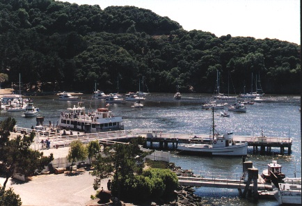
Environment. The pier is located in Ayala Cove on the north side of the island; it fronts on Raccoon Strait, and sits almost directly across the water from the Elephant Rock Pier. The pier was built in the ‘70s and is basically L-shaped. However, a dock connects to the left side of the end (for the loading and unloading of the ferries) that creates a T-shape effect. The main stem of the pier faces west and is approximately 150-foot-long but then the pier turns north and reaches out another 100 feet into deeper water. Although relatively short as piers go, water can be over 20 feet deep at the end (which shouldn’t be too surprising since water reaches a depth of over 200 feet in the narrow, half-mile-wide Raccoon Strait). Most structure pilings are concrete, as is the surface, but there are also wooden pilings along the side of the pier and all pilings are heavily encrusted with barnacles and (some) mussels.
Along the shoreline, the bottom is primarily rocky (and covered with algae during summer months). Between the shoreline and the outer parts of the pier is a tidal basin of moderate depth that has a mud bottom, although there are also a few rocks and old pilings that will snag lines. The bottom, away from the pier, is also mud and shows a rapid drop-off in depth.
The most common fish are brown rockfish (which at times can seem to cover the bottom of the inshore tidal basins), and staghorn sculpin (bullheads) which at times can seem to cover the bottom of the deeper waters away from the pier. In the rocky inshore areas, anglers will also encounter perch (black, white, pile, striped, rubberlip and rainbow) and jacksmelt.
Casting away from the pier will yield a lot of sharks (primarily brown smoothhound, leopard and spiny dogfish), bat rays, skates, white croaker (kingfish), sanddabs, a few starry flounder, and even an occasional lingcod.
Less common are striped bass and halibut, although both are distinct possibilities. Sturgeon are in these waters nearly year round (but especially during the winter) and salmon move through these waters in the fall, but I haven’t heard of any being caught from the pier.
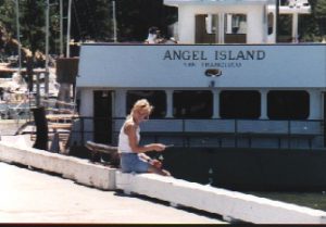
My daughter Kim gives it a try.
Fishing Tips. Best times for the perch are the winter and spring months. Keep the hooks small (size 4, 6, or even 8) and use pile worms, grass shrimp or fresh mussels for bait. Best spots for the perch are the inshore sections by the shoreline rocks during high tide, in the tidal basins themselves, or directly under the pier. Fish on the bottom using a high/low leader and remember that if a perch starts to tap a bait you need to be patient, let the perch hook themselves. Blackperch are the most common perch, but if the large rubberlip are around, consider using a motor oil or root beer colored rubber grub as a lure. Drop the grub to the bottom and then jig it up and down. You may not get as many fish, but often the ones you catch will be large, trophy-size perch. One place to try for perch is where two pilings stick up out of the water on the right side of the main stem of the pier; it is an ideal spot and has proven productive in the past.
Brown rockfish can bite year-round, although there seem to be two distinct populations of fish at the pier. In the winter and spring you will mainly find perch in the tidal basins with fewer numbers of rockfish. However, the rockfish will often be good sized (at least for brown rockfish). In the summer and fall, the tidal basins will often be thick with brown rockfish but most will be fairly small. In the winter and spring a size 4 hook with shrimp or worms will yield the rockfish; in the summer or fall a size 6 hook with pile worms is by far the best bait. In the tidal basins, simply cast out and let the bait reach the bottom. If there is no bite after a few seconds, begin a slow retrieve stopping every couple of feet. Usually action will be fairly rapid, especially if you are using a shiny sinker that can attract the fish. You can also drop your leader straight down alongside the pier. Best results seem to occur if you keep your bait a foot or so off the bottom.
Sharks and rays can be caught at almost any section of the pier but the best action is in the deepest water. For these, be sure to use larger hooks, size 2 to 4/0, larger baits (especially squid), and have a way to land the large fish, a gaff or a net. Remember that the leopard sharks must be at least 32 inches in length.
White croaker are generally caught on cut anchovies fished in the deeper water. Use a size 4 or 2 hook, a high/low leader and a shiny sinker. Sanddabs will hit a small bait fished on the bottom. Starry flounder prefer grass shrimp fished on the bottom using a sliding sinker. The key to a lot of these bottom fish is keeping the staghorn sculpin off your hook (although they are not as bad in the winter and spring). Jacksmelt hit on pile worms or small pieces of shrimp fished under a bobber (or float).
Striped bass are one of the prizes from local waters. Most anglers simply throw out a chunk of sardine or a whole anchovy. Far better is a live shiner or a staghorn sculpin (bullhead) hooked on the end of a live bait leader. Halibut will also fall for this rigging although they prefer a shiner or a small smelt. Artificial lures may also land a few stripers; lures proven to be successful include Fish Trap Lures, Rat-L-Traps and bucktail-type lures such as Hair Raisers. Although the number of keeper-sized stripers are far down from previous years, this is a good area for the silver sided beasts.
If you want to try for sturgeon, and they should be available, try herring eggs, ghost shrimp, mud shrimp or grass shrimp, and fish the deepest waters away from the pier. Be prepared with a net in case you luck into one of these large critters.
<*}}}}}}}}}>< — Special Bay Area Regulations:
- A perch closure exits in San Francisco and San Pablo Bay from April 1 to July 31. No perch may be kept other than shinerperch (20).
- In San Francisco and San Pablo Bay a fishing line may not contain more than three hooks.
Sturgeon Regulations:
- A sturgeon report card and tags are required for anyone fishing for or taking sturgeon. (a) The card must be in the angler’s possession; (b) a tag must be used for any sturgeon retained by the angler; (c) the angler must record information on the Sturgeon Report Card immediately after catching and keeping or releasing the sturgeon.
- White sturgeon can only be kept from 40-60 inches; larger and smaller sturgeon must be released.
- Green sturgeon may not be taken or possessed.
Potpourri —Perhaps more than you want to know about the Angel Island Pier
<*}}}}}}}}}>< — There are a lot of sharks in the deep waters that surround Angel Island but you rarely hear about a thresher shark which is what this story is really about, not a man-eater shark.
Baby Shark Captured — The Youngest Netted By Fishermen Off Angel Island —
First of the Man-Eating Species Ever Caught in the Bay of San Francisco
A baby shark of the man-eating species, commonly called the basking shark, but known best to fishermen as the Manila shark, was caught near Angel Island last Thursday by Captain Maggio. The fisherman had quite a struggle to capture the ferocious youngster. The young shark is seven feet in length from the head to the extreme point of the tail and weighs fifty pounds. The tail is about three and a half feet long. Sharks of this species grow to immense size, weighing from 600 to 1000 pounds each.
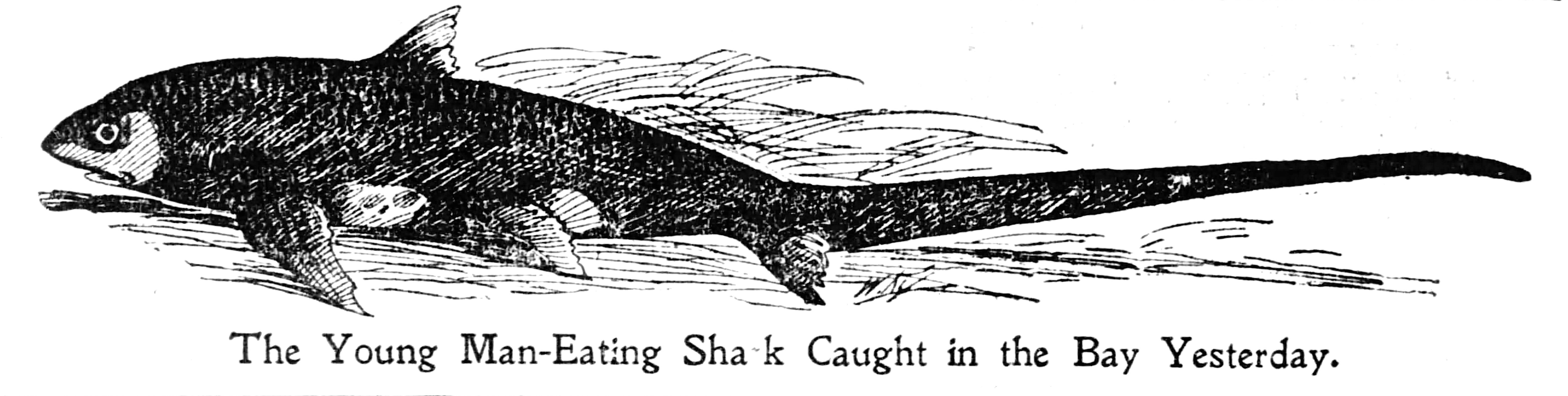
The baby shark from which the accompanying sketch is made is on exhibition at J. B. Inguelia & Co.’s, 520 Merchant Street, and will remain there day-to-day.
The statement is made by the fishermen that this is the first of the man-eating sharks ever caught in the Bay of San Francisco, although they are common enough in southern waters off the coast of Mexico and Central America. It is surmised that this young fellow lost the school to which he belonged and in seeking for warmer waters entered the bay. He is well equipped with three rows of teeth. The fishermen estimate that he was able to strike a 300-pound blow with his tail.
—San Francisco Chronicle, July 18, 1897
History Note. The island was named by the Spanish explorer Don Manuel de Ayala who sailed his small craft, the San Carlos, into these waters in 1775. He named it “Isla de Nuestra Senora de los Angeles” which was shortened to Los Angeles Island and then to Angel Island by Americans in the 1800s. The first human residents of the island were apparently the Miwok Indians who cheerfully greeted Ayala upon his arrival at the cove. Little did they know the changes that would soon take place. In 1839 the island was granted to Antonio Maria Osio.
In the mid-1800s the U.S. military expelled Osio and established Camp Reynolds, one link in the chain of defense that protected the critical entrance to San Francisco Bay. After the Civil War, the camp served as a recruit depot for the “Indian Wars” of the 1870s and 1880s. Between 1898, the start of the Spanish American War, and the end of World War II, it was the site of one of the world’s largest induction centers, although it was renamed Fort McDowell in 1900.
From 1892 until the end of World War II in 1946, Hospital Cove (today’s Ayala Cove) served as the site for the U.S. Quarantine Station; passengers from “contaminated” vessels would have the pleasure of being fumigated and cleaned at the government’s expense.
From 1908 to 1940 the infamous Immigration Station near Point Simpton served as the entry spot for those entering the West Coast. Infamous because of the disparity in treatment shown the different ethnic groups. While Europeans were individually housed and generally given quick approval, Asians were crammed into barracks by the hundreds, often for indefinite periods. Pictures in the restored barracks display the shame and embarrassment of many who had lost their privacy and dignity. But pictures also show the hope for an improved future that drove the people to travel the thousands of miles to California’s shores.
After World War II the island was declared government surplus. Soon after, in the early ’50s, voters in San Francisco voted to annex the island as a park. But before that could happen, the Cold War intervened and the army decided to reactivate Fort McDowell, flatten Mount Ida, and use it as a Nike (Goddess of Victory) missile site. The missiles were installed in 1954 but removed just eight years later in 1962 when the army once again left the island.
During the fifties, the State Park Commission had acquired the Hospital Cove area (renaming it Ayala Cove) and began to develop the site as a park. When the military left in 1962, the remaining areas of the island were added to the state park.
Angel Island Pier Facts
Hours: The pier is open from 9 A.M. till sunset. Although the island is open 24 hours a day (and campsites can be reserved), most visitors arrive and depart based upon the ferry schedules. The Tiburon ferry generally makes the 10-minute run to the island hourly between 10 A.M. and 3 P.M. (5 P.M. during the weekend and summer) and returns 20 minutes after each of those hours.
Is crabbing available at Angel Island!
You can crab from the pier near the landing but only for rock crabs, not Dungeness.
I fished the pier at Angel Island in October of 2024. Mainly there for the touring and sight seeing, but threw a line in for 30 minutes. I caught one nice size smelt on cut anchovie. I will definitely head back. Not so sure how productive this pier is for fishing, but it is one of those “bucket list” places that any “pier rat” has to try. There is a snack bar and restrooms adjacent to the pier, which adds convenience to the location.
Olá, comecei a procurar um casino online depois de ouvir opiniões bem diferentes de pessoas próximas. Queria testar algo por mim mesmo, mas com cuidado e sem exageros. Ao ler sobre rolldorado, decidi visitar o site e analisar melhor. Vi bônus específicos para Portugal, algumas promoções rotativas e condições que não parecem feitas só para confundir o jogador. O que me agradou foi poder navegar tranquilo, sem pressão ou mensagens insistentes.
That 20 foot depth at the end of the pier sounds pretty solid for fishing.
Qwen Image 3.0 is basically that friend who shows up with exactly the right meme without you asking—it generates AI images straight from your workflow prompts. Perfect for when you need a quick visual for a Reddit shitpost or want to see what a cat in a business suit looks like without firing up a heavy tool.
Qwen Image 3.0 is basically the AI artist that finally understands my weird requests for “a cat wearing a top hat in a cyberpunk alley” without glitching out. It’s perfect for rapid prototyping visuals or just generating memes that actually look good.
The ferry schedule alone makes this pier a bit of a commitment—planning around the last boat costs you more patience than any bait.
The historical background of Angel Island adds a unique layer to visiting the pier. It is interesting that it stands as the only public pier in Northern California situated directly on an island, especially with its distinctive vantage point across Raccoon Strait in Ayala Cove. Blending the deep history of the West Coast Immigration Station with a dedicated spot for pier fishing makes it a truly unique destination.
The description of the L-shaped pier and the adjoining ferry dock makes the layout much easier to picture. Pairing that explanation with the family photograph gives the article a sense of place beyond a list of species and fishing spots.
The distinction between the rocky shoreline, muddy tidal basin, and deeper water beyond the pier makes Ayala Cove much easier to visualize. Those details would also be useful references for a coastal game setting, especially when keeping an angler character recognizable across different scenes.
The explanation of the ferry dock creating a T-shaped effect on the L-shaped pier is useful for understanding the layout. A small labeled sketch showing the loading area and the different shoreline zones would make those details easier to remember. Since the article dates from 2018, a clearly dated access update would also help readers separate the historical description from arrangements that may have changed.
The description of the L-shaped pier and the ferry dock creating a T-shaped effect makes the layout much easier to picture. A small annotated plan beside the photographs would help readers connect the shoreline, tidal basin and outer end without treating the images as interchangeable views. Dated captions would also make the historical photographs more useful as an archive.
The personal photographs and the detailed description of the tidal basin make this more than a list of fishing spots. For an archive, I would keep people and other context in the original images, since they show how the pier was used at that time. A separate diagram is a better place to simplify the layout than an edited documentary photograph.
The description of the pier’s L-shaped structure and the ferry dock makes the location much easier to picture. A simple annotated map beside that section would help readers connect Ayala Cove, the landing area and the shoreline. For a narrated introduction, I would keep the historical stories separate from practical access information and clearly date each part.
The description of the L-shaped fishing pier alongside the ferry dock helps explain the layout at Ayala Cove. A small labeled map separating the ferry loading area from the pier would make those directions much easier to picture. Since the page carries a 2018 modification date and flags access as unclear, placing a link to the park’s current access information beside that note would also help readers plan their visit.
Why does the pier depth of 20 feet at the end matter so much for bait choice? I usually start with bottom rigs in deeper water, but the quick drop-off suggests checking depth before changing bait.
The distinction between the rocky shoreline, the muddier basin and the deeper water beyond the pier is useful for understanding why one spot can fish differently from another. A simple labelled sketch would make those changes easier to connect with the L-shaped pier description.
The account combines local history with a very detailed description of the pier itself. Keeping dated historical observations separate from a clearly updated access-information box would help visitors enjoy that context while knowing which practical details still need checking before a trip.
The explanation of the L-shaped pier and the ferry dock helps make sense of the layout before looking at the fishing details. A simple plan marking the shared boarding area would be a useful companion to the measurements and depth description.
The historical introduction gives the pier a context that a list of fishing spots would miss. Linking the island’s earlier role with the present-day park makes this feel like a place to understand, rather than just a location to mark on a map.