El Nino is Here
- Thread starter Once You're Hook
- Start date
A very strong El Niño pattern is currently developing offshore, with a Sea Surface Temperature (SST) anomaly of 4-5°C in the equatorial Eastern Pacific. Very classic El Niño pattern as opposed to a negative SST anomaly characteristic of normal/La Niña conditions. Of additional interest is the enormous blob of unusually warm water in the Northeastern Pacific that will soon be barreling down the West Coast. It was significantly warmer a few weeks ago (>6°C SST anomaly!!!), but has since cooled down somewhat.
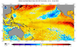
Closeup of the Central Pacific showing the classic El Niño SST anomaly pattern, and also showing the southern half of the warm water mass in the Northeastern Pacific.
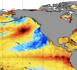
Closeup of SST anomaly in the Eastern Pacific indicating the early stages of development of an El Niño, with remnant cool water from last year's La Niña and the horrifying blob of blood-red death looming ominously in the Northeastern Pacific.
Source: https://www.ospo.noaa.gov/Products/ocean/sst/anomaly/

Closeup of the Central Pacific showing the classic El Niño SST anomaly pattern, and also showing the southern half of the warm water mass in the Northeastern Pacific.

Closeup of SST anomaly in the Eastern Pacific indicating the early stages of development of an El Niño, with remnant cool water from last year's La Niña and the horrifying blob of blood-red death looming ominously in the Northeastern Pacific.
Source: https://www.ospo.noaa.gov/Products/ocean/sst/anomaly/

